Improving irrigation water requirements by means of Earth observing satellites
In the Communication on water scarcity and droughts, adopted in July 2007, the Commission mentioned that water scarcity and drought are an increasingly frequent and widespread phenomenon in the European Union. According to the European Environment Agency, the highest pressure on surface and subsurface water resources is exerted by the agriculture sector, which consumed 59% of total water use in Europe in 2017. The largest water volumes (95%) were used in Southern Europe, including Turkey and the Western Balkans. In this context, the water management in agriculture has become a key theme for dealing with the challenge of water scarcity intensification.
Earth observation satellites for irrigation
Irrigation is the largest consumer in the agriculture sector, and the efficient use of water is of utmost importance. Earth observation satellites offer the capability to monitor different variables related to irrigation, such as soil moisture, evapotranspiration, rainfall, vegetation, etc.
The capability to assess surface soil moisture at a global scale has improved significantly since the 1970s thanks to the development of microwave remote sensing. Microwave remote sensing, consisting of passive and active options, is one of the most effective tools for monitoring soil moisture over large areas. The passive sensors measure the intensity of a soil’s microwave emission, expressed in terms of brightness temperature, with high temporal resolution but at coarse spatial resolution, whereas the active sensors measure the backscattering power at high spatial resolution but it is limited by low temporal resolution.
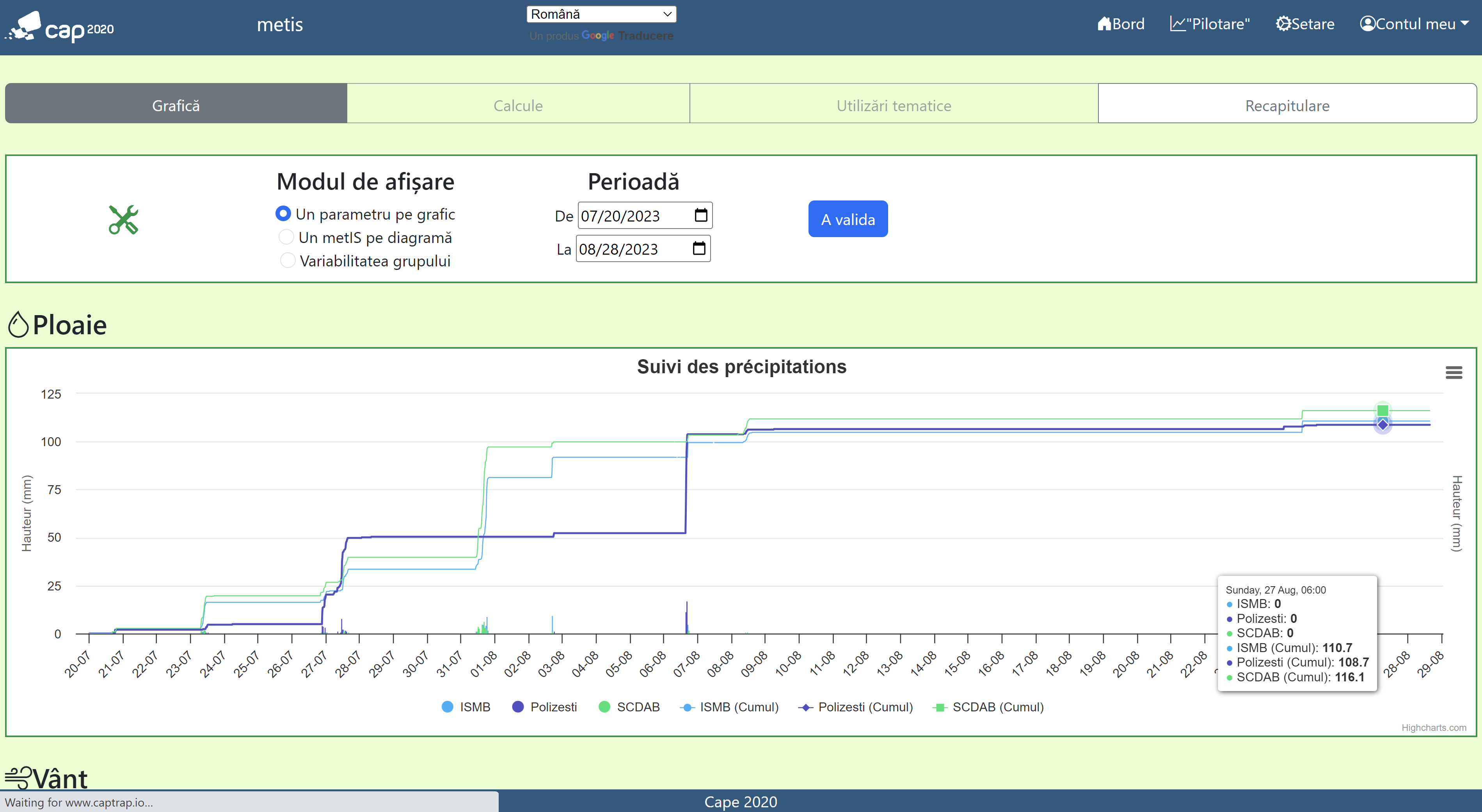
In the framework of MAGDA Project, one of the key outcomes is to provide irrigation advisory based on the hydrological modelling and EO data. Copernicus Surface Soil Moisture (SSM) 1 km ([1]), retrieved from backscatter values provided by Sentinel-1 C band SAR active sensor, is being assessed for monitoring irrigation water use.
Evaluation of satellite soil moisture for irrigation in Romania
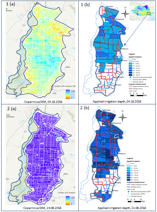
Copernicus SSM has been tested over Embanked Great Island of Danube River (72 ha), Braila, Romania, for the 2017-2018 crop year, one of the most important irrigated areas in Romania. Weekly comparison of applied irrigated water volumes and satellite soil moisture (Fig.1) showed a good agreement between the two datasets: application of low water irrigation depth in April corresponds to low satellite soil moisture values (Fig. 1.1(a-b)), when only autumn wheat was irrigated (10-20 mm), while at the end of June, the summer crops development required high water irrigation depth (40-50 mm), inducing high satellite soil moisture values (Fig. 1.2(a-b)).
[1] https://land.copernicus.eu/global/products/ssm
Conclusion
Evaluation of different satellite soil moisture products using in-situ data will improve understanding of how the water irrigation is applied in the field and how it can be adjusted in order cover the crop water requirements. In the future, irrigation decision makers from Braila County could combine satellite soil moisture products and in-situ data to choose the right place and the right moment for applying irrigation according to crop water needs and water resources with the assistance of MAGDA solutions.
Author: Zenaida Chițu, PhD
References
Chitu, Zenaida, Fausto Tomei, Giulia Villani, Alessandro Di Felice, Giovanni Zampelli, Ioan Caton Paltineanu, Ioan Visinescu, Alexandru Dumitrescu, Marcel Bularda, Dumitru Neagu, and et al. 2020. “Improving Irrigation Scheduling Using MOSES Short-Term Irrigation Forecasts and In Situ Water Resources Measurements on Alluvial Soils of Lower Danube Floodplain, Romania” Water 12, no. 2: 520. https://doi.org/10.3390/w12020520
Grumeza, N.; Kleps, C.; Merculiev, O. Prognoza și Programarea Aplicării Udărilor în Sistemele de Irigații; Editura Ceres: București, Romania, 1989. (in Romanian)
Visinescu, I. Irigația pe Solurile cu Aport Freatic Din Insula Mare a Brăilei; Casa Agronomului: Brăila, Romania, 1978. (in Romanian)
Links
https://land.copernicus.eu/global/products/ssm
https://land.copernicus.eu/global/sites/cgls.vito.be/files/products/CGLOPS1_PUM_SSM1km-V1_I1.30.pdf
Keywords
Irrigation, satellite soil moisture, applied water irrigation, Embanked Great Island of Danube River, Braila, Romania